What if you could instantly identify the communities most at risk from hurricanes or pinpoint where disaster response resources should go? Google Earth AI is attempting to bring this vision to life by merging advanced geospatial AI models with powerful reasoning agents. The result is actionable, holistic insights delivered in seconds.
Foundation Models: Multi-Domain Intelligence
At the heart of Google Earth AI lies a suite of cutting-edge foundation models, each expertly trained on massive datasets. These models analyze satellite imagery, population trends, and environmental data. The real breakthrough comes from fusing their strengths to enable cross-modal reasoning helping to unlock insights no single model could provide.
- Imagery Model: Harnesses vision-language technology for open-vocabulary object detection and image analysis. Trained on high-resolution satellite images paired with descriptive text, it lets users ask natural questions like “find all flooded roads” and receive accurate, rapid results. This model boasts a 16% improvement in text-based image search and more than double the baseline accuracy for spotting new types of objects.
- Population Model: Delivers a deep understanding of human movement and density, with globally consistent, regularly updated data across 17 countries. These insights are crucial for predicting trends like disease outbreaks, demonstrated by a 44% leap in dengue fever forecast accuracy in Brazil.
- Environment Model: Provides hyperlocal forecasts for weather, monsoons, air quality, and floods, now reaching two billion people worldwide. Accurate forecasts support both disaster preparedness and daily environmental monitoring.
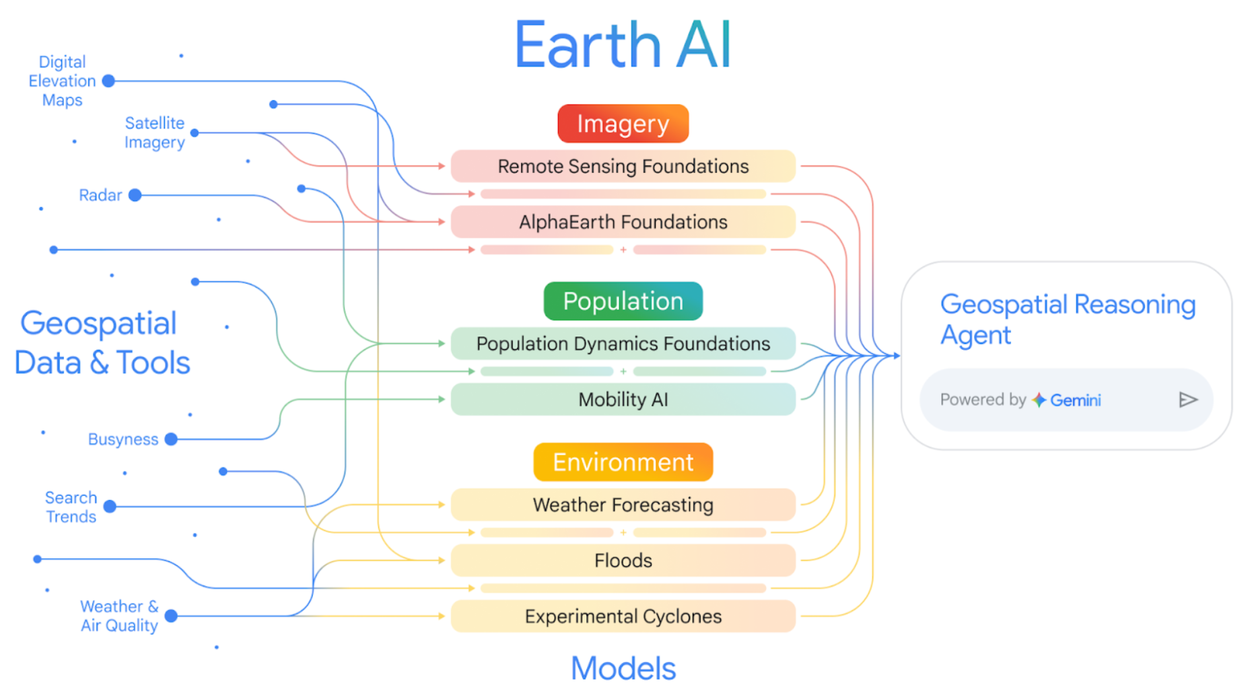
Image Credit: Google Research
Fusion Leads to Superior Decision-Making
While each model excels individually, their integration sets a new standard for geospatial intelligence. Google found that combining population and landscape data improved FEMA’s National Risk Index predictions by 11% overall, and even more for specific hazards like tornadoes and flooding. This synergy delivers more nuanced, actionable insights for risk assessment and planning.
Gemini Agents: Advanced Geospatial Reasoning
To answer complex, real-world questions, Google Earth AI employs a Gemini-powered Geospatial Reasoning agent. This system translates natural language queries into multi-step plans, coordinating sub-agents and geospatial tools. Whether assessing storm risks or analyzing critical infrastructure, the agent pulls from imagery, population, and environment models for transparent, step-by-step answers.
Benchmarks underscore this approach: the agent achieved a 0.82 accuracy score in fact-based Q&A, outshining general-purpose AI solutions. In disaster response, its ability to synthesize diverse data sources proved vital for timely, informed decisions in crisis management and public health.
Impact in the Real World
Google Earth AI is already delivering practical benefits. Projects like Bellwether use it to estimate storm damage for insurance payouts. The United Nations Global Pulse leverages rapid damage assessments for faster disaster response. Humanitarian groups, including GiveDirectly, rely on its flood forecasts and population models to target vulnerable communities and direct aid efficiently.
Google is also empowering partners such as Khushi Baby and Cooper/Smith to model infectious disease spread and improve health interventions globally. Businesses like Public Storage and CARTO are integrating Earth AI into their strategic planning and geospatial analytics workflows.
Ushering in a New Era of Geospatial Intelligence
Google Earth AI represents a paradigm shift in planetary understanding and management. Its multimodal, reasoning-based framework allows organizations to transcend isolated analysis, enabling data-driven responses to climate, disaster, and public health challenges at unprecedented speed and scale. As Google continues to open access to these tools for developers and enterprises, the stage is set for unprecedented collaboration and innovation in solving global challenges.


Google Earth AI: Transforming Geospatial Insight Through Foundation Models and Cross-Modal Reasoning