Introducing AlphaEarth Foundations, a groundbreaking AI model from Google DeepMind that provides the most detailed look at Earth to date. By integrating massive volumes of Earth observation data, AlphaEarth Foundations serves as a "virtual satellite," creating a unified, detailed digital portrait of our planet's land and waters.
Taming the Flood of Satellite Data
Modern satellites generate enormous and complex datasets, ranging from images and radar to 3D models and climate information. Traditionally, merging and making sense of this data has been a daunting challenge. AlphaEarth Foundations overcomes this by blending dozens of public data sources and analyzing the globe in precise 10x10 meter squares.
Its most notable advancement is the creation of efficient data summaries, called embeddings, which use 16 times less storage space than earlier systems. This innovation dramatically reduces the logistical and financial barriers to large-scale planetary analysis.
Consistent Insights, Even in Challenging Environments
With AlphaEarth Foundations, researchers and policymakers gain access to consistent, high-resolution maps that reveal both subtle and significant changes over time. The model can penetrate persistent cloud cover, as seen in Ecuador’s farmlands, and accurately map remote regions like Antarctica.
It also detects hidden shifts in agricultural land use, offering a comprehensive and actionable view of global change. These strengths are especially vital for monitoring food security, tracking deforestation, managing urban expansion, and safeguarding water resources.
Proven Performance and Widespread Adoption
AlphaEarth Foundations has undergone rigorous testing against conventional and AI-based mapping systems, consistently delivering a 24% lower error rate even with minimal labeled data.
Its efficiency, precision, and ability to produce detailed maps on demand mark a new benchmark for geospatial analysis. Over 50 organizations have piloted the technology, noting remarkable improvements in mapping speed, accuracy, and the classification of previously unmapped ecosystems.
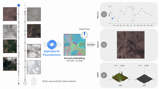
Diagram showing how AlphaEarth Foundations works, taking non-uniformly sampled frames from a video sequence to index any position in time. This helps the model create a continuous view of the location, while explaining numerous measurements. (Credit: Google)
Empowering Research with the Satellite Embedding Dataset
To encourage broad adoption, Google DeepMind has released annual AlphaEarth Foundations embeddings as the Satellite Embedding dataset via Google Earth Engine. This repository holds over 1.4 trillion embedding footprints each year, empowering leading organizations worldwide:
- Global Ecosystems Atlas: Supports countries in mapping and prioritizing conservation and restoration of uncharted ecosystems.
- MapBiomas (Brazil): Provides deeper insights into agricultural and environmental changes, particularly in vital biomes like the Amazon.
- Research institutions: From the United Nations Food and Agriculture Organization to Stanford University, experts are leveraging the dataset for advanced classification, biodiversity monitoring, and sustainable development planning.
Feedback has been overwhelmingly positive, highlighting faster, more accurate, and more adaptable map production, transforming environmental monitoring and strategic decision-making.
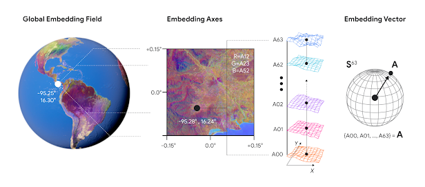
Diagram showing a global embedding field broken down into a single embedding, from left to right. Each embedding has 64 components which map to coordinates on a 64-dimensional sphere. (Credit: Google)
Looking Ahead: The Future of Geospatial Intelligence
AlphaEarth Foundations is more than an AI tool; it's a springboard for global research, action, and innovation. Google DeepMind is already exploring the integration of AlphaEarth’s time-based data with powerful reasoning AI, such as Gemini, under the Google Earth AI initiative. These efforts aim to provide robust, scalable, and accessible geospatial intelligence to address the world’s most urgent challenges.
Takeaway
AlphaEarth Foundations represents a leap forward in our ability to observe and protect our changing world. By making detailed, standardized, and actionable data widely available, it paves the way for breakthroughs in science, conservation, and sustainable development. The next generation of planetary mapping is here and it’s driven by AI.
Source: Google DeepMind Blog
Paper: https://arxiv.org/pdf/2507.22291


AlphaEarth Foundations: Ushering in a New Era of Planetary Mapping Powered by AI